Work Program
SAFEWAY is a Research and Innovation Action (RIA) and as such, it includes knowledge generation, technology development activities (based on the results obtained in previous R&D projects) followed by very important prototyping, and use-cases testing. The distribution of the project time is done in 3.5 years, highlighting the main aspects of each part of the project.
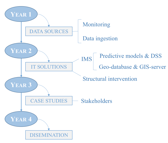
Year 1: During the first year of development the activities will be focused on collecting the data needed for the next phase. The sources of data are distributed in four main groups: potential hazards (natural and human-made); infrastructure inspection; innovative multi-scale condition monitoring systems; and the crowdsourcing concept, for both real-time infrastructure monitoring using connected vehicle data, and human sensing approaches.
Year 2: The prototype of Infrastructure Management System (IMS) will be developed. This is an interoperability service oriented solution to support the evaluation of the data collected.
Year 3: SAFEWAY innovation will be validated in 4 near-real life scenarios in order to test and validate effectiveness and transferability. SAFEWAY proposes four case studies along five corridors of the European core network (TEN-T).
Overall structure of the work program.
SAFEWAY project duration is 42 months. The project work plan is divided into 10 work packages.
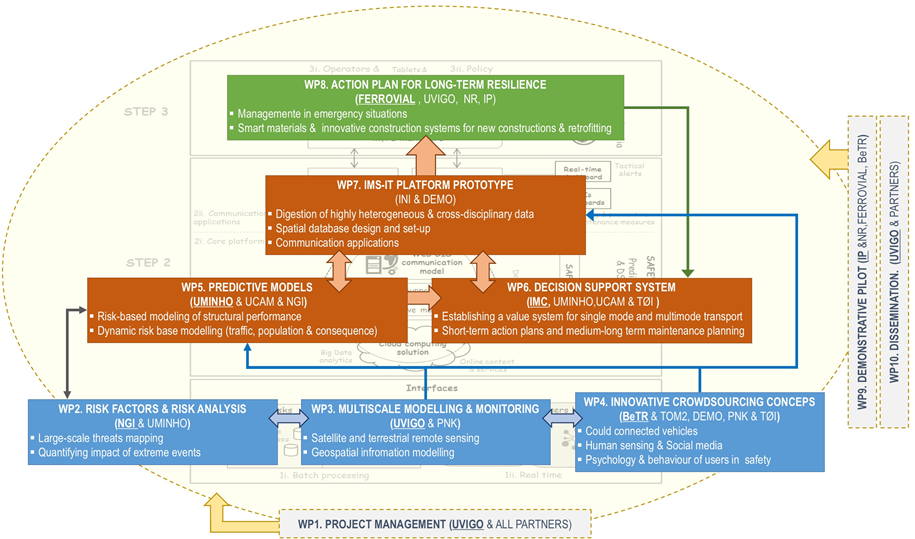
WP1 "Project management" ensures a proper management and coordination of the project and its activities. Inputs to the core system will provide by WP2-4.
WP2 "Risk factors and Risk Analysis" deals with identification of risk factors, extreme weather conditions and climate risks, analysis of statistics and prediction models (long term and short term, as well as development of guidelines to detect and monitor the signs of occurrence of an event.
WP3 "Multiscale Modelling and Monitoring" is dedicated to multi-scale monitoring of infrastructure condition by merging geospatial data of different nature (satellite and terrestrial mobile mapping systems (including both at network scale and facility scale), big data approaches to optimally handle the huge amount of information together with advanced computer vision and machine learning techniques to automatically feed the information models of the infrastructure.
WP4 "Innovative Crowdsourcing Concepts" focuses on alternative sensing approaches that involve the sensing performed by the users and social media, both the technologies of connected vehicles and data shared through social media, with the objective to deliver traffic information with similar accuracy as infrastructure based-methods and to automatize their satellite monitoring.
WP5 "Predictive Modelling" develops predictive models considering all dimensions of monitoring efficiently; multi-physics, big data, etc. It is divided in two scales of prediction/analysis; i) climate/meteorological short-term predictive models and ii) long-term predictive models for structures.
WP6 "Decision Support Systems" develops a robust decision support framework to provide both a medium to long-term maintenance planning, to plan optimal maintenance actions facing extreme event scenarios; and a short term action planning, in the case of an imminent sudden event.
WP7 "IMS-IT Platform Prototype" deals with the development of the GIS-based Infrastructure Management System (IMS), after digesting all the highly heterogeneous data provided by the previous WP with the purpose of implement the services of impact quantification, decision making at both short-term and long-term scale (including maintenance planning, intervention either preventive or palliative. The GIS-based IMS will at the same time provide information to the users (infrastructure manager/operators and individual users (accounting for psychological and behavioural variables that are potentially protective). The Level of Service (LoS) in terms of resilience and its sub-factors such as availability will be defined following ISO 5500x. The level of fulfilment of LoS goals will be presented in summary (and as a whole) for each part of the infrastructures in GIS, as well as forecast and other collected data.
WP8 "Action Plan for Long Term Resilience" addresses an action plan to ensure the continuation of previous developed essential services, and emergency management planning to guarantee adequate response procedures in place to deal with climate and man-made extreme events.
WP9 "Demonstrative Pilots" demonstrates the performance of the expert system on real conditions and drills. Four demonstrative pilots are envisioned, that will consist of the mapping of vulnerable areas in the European core network to test the SAFEWAY concept under different potential extreme events: flooding and land displacement in UK, The Netherlands and Spain; wildfires in Portugal, seismic and terrorism impact in Spain. These pilots include both single mode of terrestrial transport, as well as multimodal demonstration (particularly in the Port of Rotterdam where sea, road and rail infrastructure will be evaluated).
Finally, WP10 "Dissemination" deals with the dissemination and exploitation of the project results through public events.